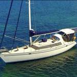
Hi, if you were sailing around the Australia coastline in a 30 foot yacht (all the way), starting in Sydney Harbour Jan1 and returning to Sydney Harbour Dec 31st...which way would you go and why? So Jan 1, Sydney Heads, turn left (north) or right (south)?
I don't have much knowledge on this so I like to get advice from sailors who have done this OR have done sections of the coastline.
I would assume direction (with the above start/stop dates) would come down to best seasonal winds/direction, currents, weather (summer/winter), storm/cyclone seasons etc.
Cyclone season normally Nov-April for the tropics (Qld, NT, Northern WA).
East Coast lows are normally May-Aug for NSW/south Qld/ eastern Vic coast
I would think prevailing wind direction and currents would be the key factor in determining if the trip would be clockwise (turn right and head south) or counter-clockwise (turn left and head north)
Also if someone has done this already and done a blog or book on it I'd love to know.
Go swell.

I think I would go clockwise too , and catch the bight in summer conditions ,
I thought I read somewhere east to west beginning of the year and west to east At the end of winter .
check your historical wind roses for the GAB.
Select to expand quoteCharriot said..
You would southace, we talking 30 foot yacht.
Yeah why not, Jan till the end of April is a time to passage Southern waters and March is usually good with SE to E breezes.
If you turn left in Jan, you are heading into the wind and the cyclone season.
I would want something bigger than a 30 footer. There are some long hops between drinks.
Select to expand quotecisco said..
would want something bigger than a 30 footer. There are some long hops between drinks.
So would I, but a bloke did it in a Top Hat a couple of years ago.
Rob Lovelace on Sundowner, TopHat 25
He went unticlockwise,
Distance:14,000 kms / 7,560 Nautical Miles
There are a few things to consider.
1. Typhoon season.
2. Currents
3. Predominant winds.
www.bom.gov.au/climate/averages/wind/wrspr9.shtml
Here is a sample of the winter wind map. Of course it is inland and coastal, but a bit of searching and you will get better info No matter which way you go, ( Anti-clockwise to avoid winter in the bight.
clockwise to be clear of the typhoons.) you can bet on 50% against wind or current so it is basically a toss up.
You go clockwise , you will be up north in cyclone season.
You go anti-clockwise , you will be in the bight in winter.
My suggestion. , flip a coin.
I would the anti route. After three winters sailing in Japan I know how to rug up.
gary
Select to expand quoteCharriot said..
Rob Lovelace on Sundowner, TopHat 25
He went unticlockwise,
Distance:14,000 kms / 7,560 Nautical Miles
But Rob found the west coast VERY hard. You also have to factor in that he had another yacht 30'+ with him the whole way.
Let's be positive. This guy build from ply 8 meter yacht, no engine, no radio and successfully sail around the world.

back at the turn of the century the beach de mer boats would often leave torres straight at the end of the season and travel via wa to avoid the se trades down the east coast might be 100 years later but the trades still blow
Leave in February and go south first.
only choice
Although I understand that Defiance went Sydney to Perth via the north and was trucked back from Perth when the lady on board became pregnant.
it is just 30 feet
Took me 6 months just to get to the boarder! ![]()
Which border Salty?
South, Sydney-Eden. or
North, Sydney- Coolangatta?
Gary
Select to expand quotegarymalmgren said..
Took me 6 months just to get to the boarder! ![]()
Which border Salty?
South, Sydney-Eden. or
North, Sydney- Coolangatta?
Gary
QLD / NSW
Definately head south out of Sydney. One thing in favour is the afternoon sea breezes will be in your favour for the whole of summer and the prevailing easterlies will get you across the bight.
If you get to cape York early october the trade winds have usually backed off a bit but still be prepared for some motoring during calms and some windward work.
November often has periods of a week or more of northerlies, but you have to keep moving so not much sight seeing, coz it can switch back to 25 knot SE trade wind for weeks at a time.
South of Whitsundays there is a lot more favourable weather so it usually is pretty easy from there.
i dont know much about WA but heading east across the bottom in spring/summer will mean using cold fronts because the periods of nice weather will often be seabreases on the nose, often at around 20 knots.
Watch around Esperance late summer for a cyclone that drifts into the south of WA and hooks up with a cold front. You will regret being on the ocean. Cold air and big swells will be drawn up from the south. Doesnt always happen however had a few of these over the years tear up the foreshore coastline. Be prepared well for around there. Most days were good craying with mild weather however I would be watching the forecasts closely in a 30ft boat. Lots of good bays and Islands to hide behind once past Israelite Bay. Thistle cove is a natural harbour, deep and very protected.
Select to expand quoteCharriot said..
Let's be positive. This guy build from ply 8 meter yacht, no engine, no radio and successfully sail around the world.
Yes one bloke did it but how many tried and failed. It all depends on why you are doing it. If you have some sub conscious thing to prove to someone or yourself then go without a motor. If you want to enjoy yourself, get the biggest boat you can afford and maintain
If you are serious about circumnavigating Australia from Sydney, you have to head east first and round Lord Howe Island and Ball's Pyramid. Maybe Norfolk as well.
From there head direct to Hobart.
Select to expand quotecisco said..
If you are serious about circumnavigating Australia from Sydney, you have to head east first and round Lord Howe Island and Ball's Pyramid. Maybe Norfolk as well.
From there head direct to Hobart.
So cisco, does that mean we have to round Heard Island, Cocos Islands and Christmas Islands to claim a real circumnavigation? ![]()
![]()
I suppose this is getting just a little silly, but I have to mention MacQuarie Island.
I'm also planning on a circumnavigation of Australia in the next couple of years. However I would be starting from Perth and leaving around November. Will be in a 40 footer so windward work is less of an issue. My plan would be anti clockwise and cross the bight first for the following reasons:
- my understanding is November to December is a good time for going accross the bottom West to East;
- avoids cyclone season up North from November to May;
- can have additional crew onboard for the first long leg (probably straight from Albany to Hobart).
Wanted to check whether the above makes sense. Am I missing anything? In particular the trade winds blowing on the east coasts mentioned above? The above plans would mean heading north past Sydney around February / March and past Brisbane roughly April / May.
Ilenart
PS Macquarie and Norfolk Islands will have to wait for the next trip :)
My plan would be anti clockwise and cross the bight first for the following reasons:
- my understanding is November to December is a good time for going across the bottom West to East;
There are various sources of wind. I just chose the easiest to access. www.bom.gov.au/climate/averages/wind/
I input Esperance winds in November and got this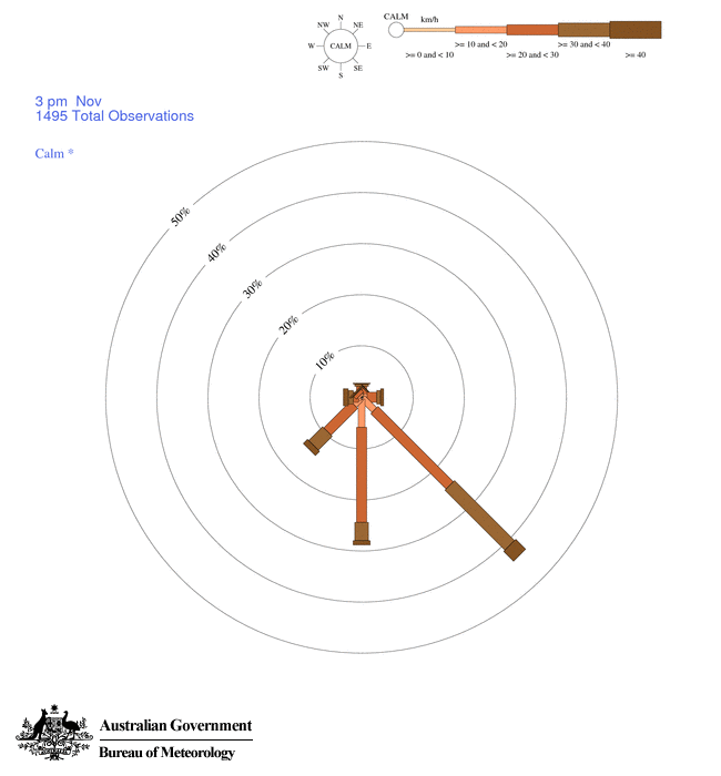
Then December and got this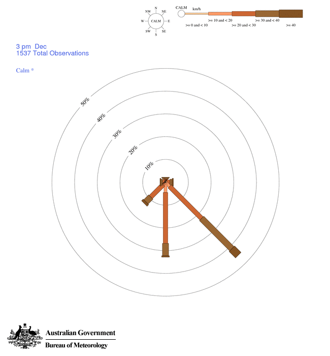
Will be in a 40 footer so windward work is less of an issue.
Less that what? Looks like a long hard slog to me.
Hope someone who has done it can jump in and fill you in.
Or that you can find an other source of information that contradicts the BOM.
gary
Select to expand quotegarymalmgren said..
My plan would be anti clockwise and cross the bight first for the following reasons:
- my understanding is November to December is a good time for going across the bottom West to East;
There are various sources of wind. I just chose the easiest to access. www.bom.gov.au/climate/averages/wind/
I input Esperance winds in November and got this
Then December and got this
Will be in a 40 footer so windward work is less of an issue.
Less that what? Looks like a long hard slog to me.
Hope someone who has done it can jump in and fill you in.
Or that you can find an other source of information that contradicts the BOM.
gary
Less than the 30 footer in the op.
Less than the 30 footer in the op.
Yep, you are right there.
Either way It is a trip I would love to do , but know I never will.
gary
thanks Gary, we were hoping next year but COVID-19 will probably delay.
"my understanding is November to December is a good time for going accross the bottom West to East;"
This is mainly from Jimmy Cornell's World Cruising Routes. IS17 is West Australia to Bass Strait and it specifies the best months from December to March. Suggests either coastal or offshore with the latter "...has the advantage of more consistent winds...". Hence my plan would be well offshore. I believe the average winds for Esperence would be effected by the local sea breeze, which should stop being a factor 30-50nm offshore.
Ilenart
Select to expand quotecisco said..
Shoot!!! We own a slice of Antarctica too don't we. ![]()
No we only claim most of it on this side.
Speaking to a delivery skipper not long ago he says sticking close to the coast when sailing east from Adelaide often gives a beam reach due to the influence of the land mass temperature. Anyone else heard this?
I sailed from Hobart to Perth in January, the trick is wait in Coffin Bay or Streaky bay until there is a high in the southern ocean, then stay about 30-40 miles from the coast across the Bight, the land creates its own weather pattern close in. It took 5 days from Streaky Bay to Middle Island, then a day of daylight sailing through the archipeligo tp Esperance. After that it 2-day/one night hops to Perth and up the coast.