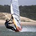
After much discussion amongst the speed crew and how we could apply the technology to wave sailing.
Starting this weekend we've decided to start doing some experimentation to see if we can utilize the GPS technology to enliven, enhance and improve wave sailing.
Some of the areas which we think the data can be utilized are:
Jumps ie height measurement
Wave riding analysis, speed on wave face, speed of turns, amount of turns etc,
It should be interesting to see the results
The last time I wore a gps in the waves I split the aquapack!
Was thinking about it for sat arvo, would mean a greater distance, and would be good to try alphas on wave gear, but I'm not convinced it's wise.
I have heard that altitude measurement with gps is woefully inaccurate. This seems to be the case with the Navi. Don't know why.
The reality of the situation is height can be easily calculated from the binary data. Speed Over Ground (SOG), or Doppler speed as some like to call it, is derived from 3-dimensional velocity measurements. Velocity, which is defined as the rate of change of position, is a vector physical quantity; both speed and direction are required to define it. Just as the gps internally calculates SOG from the data, vertical speed can also be derived which can then be converted into vertical height. The only limitation is the sampling rate of 1 hz, 1 reading per second, if you can measure at 5 or 10 hz you will get a much better indication of the precise height achieved. Post processing software can easily calculate the heights and a 3 dimensional plot can show the height and distance of each jump. I have been trialing a unit that records the velocity in 5 and 10 hz intervals. I'll see if I can extrapolate the data needed next time I go jumping.
Tried wearing the GPS wavesailing a few times, you get some interesting zig zag tracks along with spikes from wiping out.